
Photo Agency - Astronomy - Space - Nature


> Earth from space gallerie
 |
 |
SlideShow Image 1379 / 2740 |  |
 |
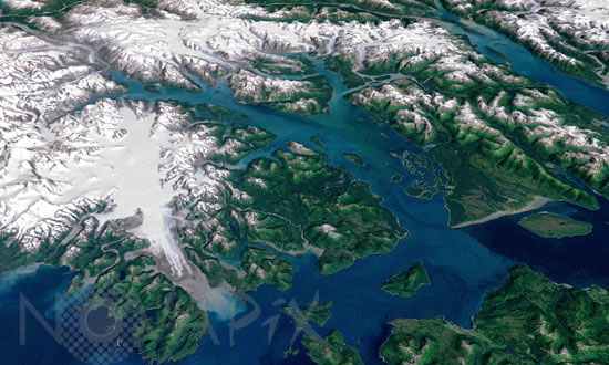
Glacier Bay in Alaska
auteur: Nasa/GSFC/USGS/Novapix
référence: t-naalk-00006
Image Size 300 DPI: 63 * 38 cm
Glacier Bay National Park and Preserve lies on the Pacific Coast of Alaska south of the St. Elias mountain range. The bay was set aside as a National Monument in 1925 and became its current National Park and Preserve in 1980, when approximately 85 percent of the park was designated a Wilderness Area. It has since been recognized as a UN Biosphere Reserve, in 1986, and a World Heritage Site, in 1992. The water in the foreground in the southwest (bottom left) corner of the image is the Gulf of Alaska, with Icy Strait running roughly west to east (horizontally) in from Cape Spencer where the strait meets the Pacific. The foreground glacier is the Brady Glacier. The light gray feature at the foot of the glacier is fine silt dropped by the glacier as it melts. The glacier's meltwater washes the silt into the Strait, coloring the shallow waters light blue as the silt mixes. The long finger of water dominating the entire scene is Glacier Bay itself. The Grand Pacific Glacier now terminates well above Tar Inlet, the finger of water stretching furthermost north (up) at the top of Glacier Bay. The first major inlet on the east (right) coming up from the mouth of Glacier Bay is Muir Inlet. The glaciers feeding into the bay terminated here around 1860. The body of water paralleling the Bay on the eastern edge is Lynn Canal, a body of water also draining into Icy Strait beyond the eastern boundary of the park. This image is a visualization created by merging imagery from the Landsat 7 satellite's Enhanced Thematic Mapper Plus (ETM+) instrument with elevation data from the USGS National Elevation Dataset (NED). This true-color image was created by combining the red, green, and blue wavelengths (ETM+ bands 3, 2, and 1). The resulting image was then draped over a visualization of the NED data with no vertical exaggeration. The USGS NED is a merged data product created from from several sources, prodominately 30-meter resolution elevation data collected by NASA's Shuttle Radar Topography Mission (SRTM).
Contact : Stéphane Aubin +33-(0)9-51-26-53-76
© Novapix - All rights reserved