
Photo Agency - Astronomy - Space - Nature


> Earth from space gallerie
 |
 |
SlideShow Image 1369 / 2740 |  |
 |
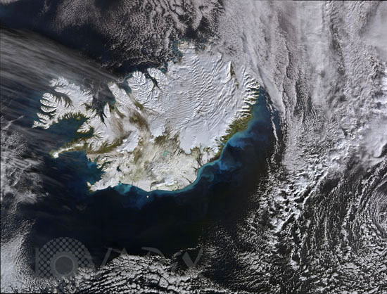
Iceland seen by satellite
auteur: ESA/Novapix
référence: t-euisl-00004
Image Size 300 DPI: 27 * 21 cm
This Envisat image, acquired on 4 October, features the island of Iceland covered in the first snow of the 2008 winter. More than 11 percent of the island is covered by glaciers. The Vatnajokull glacier, the largest glacier in Europe, is located in the southeast where the white area is more prominent. Reykjavik, the country's capital, is located in the southwest - slightly inland from the boot-shaped peninsula on the bottom left that extends out into the Atlantic Ocean. Brilliant colours of blue-green are visible swirling in the waters off the south and western coasts. These are caused by large concentrations of phytoplankton, which form the basis of the ocean's food chain and have an essential role in the global ecosystem.
Keywords for this photo:
2008 - ATLANTIC OCEAN - CLOUD - EARTH - EARTH FROM SPACE - ENVISAT - EUROPE - GLACIER - ICELAND - SATELLITE IMAGE - SNOW -
Contact : Stéphane Aubin +33-(0)9-51-26-53-76
© Novapix - All rights reserved