
Photo Agency - Astronomy - Space - Nature


> Earth from space gallerie
 |
 |
SlideShow Image 1365 / 2740 |  |
 |
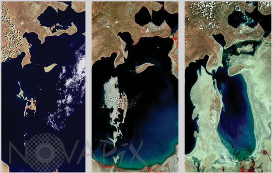
Aral sea 1977 to 2006
auteur: Nasa/USGS/Novapix
référence: t-askaz-00007
Image Size 300 DPI: 27 * 17 cm
The Aral Sea on June 4, 1977, Sept. 17, 1989, and May 27, 2006. The Aral Sea lies between Uzbekistan (to the south) and Kazakhstan (to the north). Once the fourth largest lake in the world, the Aral Sea is now less than half of its original size. The Aral Sea is a terminal, or endorheic, sea (meaning no water flows out of it). It is fed by the Syr Darya and the Amu Darya Rivers, but Soviet river diversions for irrigation made over 40 years ago have starved the Aral Sea of water. In 2001, the World Bank funded the construction of an 8-mile dam to separate the North and South Aral, and thereby save the smaller and less polluted North Aral Sea. The North Aral has been growing since completion of the Kok-Aral Dam in the summer of 2005. Repairs and updates to the inefficient Soviet-era canals have also played a role in the rejuvenation of the North Aral.
Keywords for this photo:
1977 - 1989 - 2006 - ARAL SEA - ASIA - COMPARISON - DESERTIFICATION - EARTH - EARTH FROM SPACE - KAZAKHSTAN - LANDSAT - SATELLITE IMAGE - SEA - UZBEKISTAN - WATER -
Contact : Stéphane Aubin +33-(0)9-51-26-53-76
© Novapix - All rights reserved