
Photo Agency - Astronomy - Space - Nature


> Earth from space gallerie
 |
 |
SlideShow Image 1363 / 2740 |  |
 |
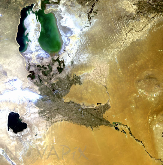
Aral sea in june 2003
auteur: ESA/Novapix
référence: t-askaz-00008
Image Size 300 DPI: 18 * 18 cm
The Aral Sea was once the fourth largest lake in the world; it began shrinking in the 1960s when the Union of Soviet Socialist Republics (USSR) diverted the Amu Darya (southern feed of the lake) and Syr Darya (north western feed) rivers to irrigate the cotton crops of Kazakhstan and Uzbekistan, with the result that the water level has dropped by 13 metres and the salinity of the water has tripled in the past two decades. Fish populations have died off, and wind-blown sand and salts threaten the entire region with the advancement of the Qyzylqum Desert (centre right of the image). Today the inland sea covers about half of its former area and its water volume have decreased by about 75 per cent.
Keywords for this photo:
2003 - ARAL SEA - ASIA - DESERTIFICATION - EARTH - EARTH FROM SPACE - ENVISAT - KAZAKHSTAN - SATELLITE IMAGE - SEA - UZBEKISTAN - WATER -
Contact : Stéphane Aubin +33-(0)9-51-26-53-76
© Novapix - All rights reserved