
Photo Agency - Astronomy - Space - Nature


> Earth from space gallerie
 |
 |
SlideShow Image 1362 / 2740 |  |
 |
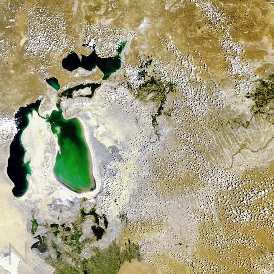
Aral sea in july 2006
auteur: ESA/Novapix
référence: t-askaz-00009
Image Size 300 DPI: 15 * 15 cm
The Aral Sea in Central Asia is shown in this Envisat image. The Aral Sea, located on the border between Kazakhstan and Uzbekistan (to the south), is actually a lake rather than a sea. Over the last 40 years, the Aral Sea, once the fourth largest lake in the world, has evaporated to half its original surface area and a quarter its initial volume, leaving roughly a 36 000 square kilometre zone of dry white-coloured salt terrain now called the Aralkum Desert. As its water level has dropped 13 metres since the 1960s, the Aral Sea has actually split into two, the larger horseshoe-shaped body of water and a smaller almost unconnected lake to its north. This Small Aral Sea is the focus of international preservation efforts, but the Large Aral Sea has been judged beyond saving (the shallowness of its eastern section is clear in the image). It is expected to dry out completely by 2020. The Small Aral Sea is still thought to be saveable, and several dikes have been constructed to cut it off from the Large Aral Sea preventing water loss and salt contamination - but shifting water levels have so far defeated these efforts. The channel connecting the two should soon dry up, preserving at least the Small Aral Sea. Meanwhile researchers are studying the salty Aralkum Desert to see how best to promote plant growth and stabilise the dusty dry lakebed. Envisat acquired this image on 14 July 2006 with its Medium Resolution Imaging Spectrometer (MERIS) instrument while working in Full Resolution Mode to provide a spatial resolution of 300 metres. The image has a width of 545 kilometres.
Keywords for this photo:
2006 - ARAL SEA - ASIA - DESERTIFICATION - EARTH - EARTH FROM SPACE - ENVISAT - KAZAKHSTAN - SATELLITE IMAGE - SEA - UZBEKISTAN - WATER -
Contact : Stéphane Aubin +33-(0)9-51-26-53-76
© Novapix - All rights reserved